
Dapeng Li
GIScientist - Software Engineer - Geographer
GIScientist - Software Engineer - Geographer
I was born in Weihai, a small city on the east coast of Shandong Province, China. I earned my Bachelor's degree in Geographic Information Systems (GIS) from the School of Information Engineering at China University of Geosciences (Beijing). My undergraduate studies mainly focused on software engineering, and I was trained as a full-stack software engineer. I hold a Master's degree in Cartography and Geographic Information Systems from Peking University. My Master's studies focused on several advanced topics in GIS: global georeferencing systems, location-based services, GIS engineering, and Web GIS. I got my Ph.D. degree in Geography (Geographic Information Science & Cartography) from the University of Utah in 2016. My doctoral training concentrated on spatial modeling/simulation, big data, and mobile computing. I did my postdoc in the Center for Systems Integration and Sustainability at Michigan State University, and my postdoctoral training focused on telecoupling and global sustainability.
I am working as an Assistant Professor of GIS in the Department of Geography at the University of Alabama. I am teaching introductory and upper-level GIS courses. As a certified GIS Professional (GISP), I am dedicated to educating the next generation of GIS professionals and helping them succeed in their career.
I have a long-running research interest in better using geospatial technologies to save life and property in disasters. My current research primarily focuses on wildfire evacuation modeling and simulation in the American West. I will continue this line of research in the next few years to build better wildfire evacuation systems in the U.S. Meanwhile, I also start to work on other topics in hazards, public health, transportation, sustainability, and agriculture.
2016
Ph.D. in Geography (Concentration: GIS, Big Data, & Mobile Computing)
Department of Geography, Univesity of Utah, USA
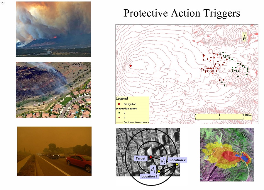
Dissertation: Modeling wildfire evacuation as a coupled human-environmental system using triggers
Advisors: Dr. Thomas J. Cova & Dr. Philip E. Dennison
2011
M.S. in Cartograhy and Geographic Information Systems (Concentration: Geoinformatics)
Institute of Remote Sensing & GIS, Peking University, China
2008
B.S. in Geographic Information Systems (Concentration: Software Engineering)
School of Information Engineering, China University of Geosciences (Beijing), China
2023 - present
Assistant Professor of GIS
Department of Geography, The University of Alabama, USA
2017 - 2023
Assistant Professor of GIS
Department of Geography & Geospatial Sciences, South Dakota State University, USA
2016 - 2017
Research Associate (Supervisor: Dr. Jianguo (Jack) Liu)
Center for Systems Integration and Sustainability, Michigan State University, USA
Project: Food security and land use: the telecoupling challenge (the Belmont Forum)
2015 - 2016
Research Assistant (Supervisor: Dr. Quynh Nguyen)
Department of Health Promotion and Education, University of Utah, USA
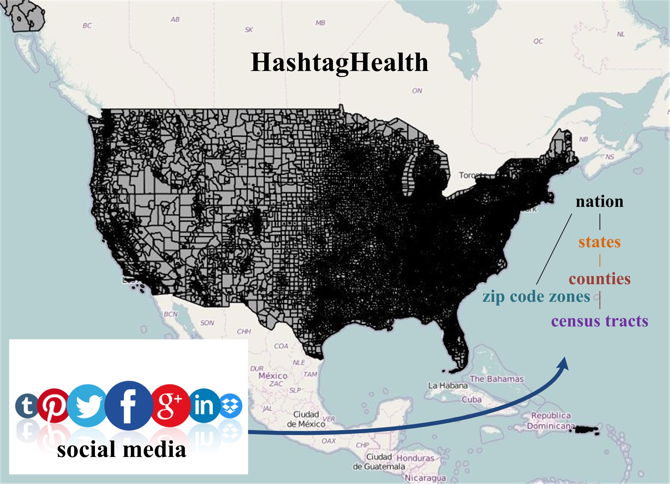
Project: HashtagHealth: A social media big data resource for neighborhood effects research (NIH)
Project website: https://hashtaghealth.github.io
2014 - 2015
Research Assistant (Supervisor: Dr. Neng Wan)
Utah Geo-Health Lab, Department of Geography, University of Utah, USA
Project: Understanding life-space characteristics based on cell-phone collected data (NIH)
2011 - 2014
Research Assistant (Supervisors: Dr. Thomas J. Cova and Dr. Philip E. Dennison)
Center for Natural and Technological Hazards (CNTH), University of Utah, USA
Project: Protective action triggers (NSF)
2008 - 2011
Research Assistant (Supervisor: Dr. Chengqi Cheng)
Institute of Remote Sensing and GIS, Peking University, P.R. China
Project: Global spatial information organization and its relevant applications
Methods:
GIS, Systems Modeling & Integration, Spatial Analysis, Big Data Analytics, Open Science
Foci:
Hazards, Public Health, Transportation, Sustainability, Agriculture
(Student Advisees Underlined)
2022
Li, Y., Li, D., & King, C. (2022). “Food Insufficiency among Job-Loss Households during the Pandemic: The Role of Food Assistance Programs”. Sustainability, 14(22), 15433. doi:10.3390/su142215433 [pdf]
2022
Li, D.* (2022). “A data-driven approach to improving evacuation time estimates during wildfires for communities with part-time residents in the wildland-urban interface”. International Journal of Disaster Risk Reduction, 82, 103363. doi:10.1016/j.ijdrr.2022.103363 [pdf][Video]
2022
Jiang, Y., Han, S., Li, D., Bai, Y., & Wang, M. “Automatic Sidewalk Trip Hazard Detection and Mapping Using Mobile Devices and Deep Learning”. Expert Systems with Applications, 227, 117980. doi:10.1016/j.eswa.2022.117980 [pdf]
2022
Jiang, Y., Huang, Y., Liu, J., Li, D., Li, S., Nie, W., & Chung I. “Automatic Measurement and Mapping of Construction and Demolition Debris Using Drones, Deep Learning, and GIS”. Drones, 6(10), 279. doi:10.3390/drones6100279 [pdf]
2022
Yue, X., Antonietti, A., Alirezaei, M., Tasdizen, T., Li, D., Nguyen, L., Mane, H., Sun, A., Hu, M., Whitaker, R., & Nguyen, Q. “Using Convolutional Neural Networks to derive neighborhood built environments from Google Street View images and examine their associations with health outcomes”. International Journal of Environmental Research and Public Health, 19(19), 12095. doi:10.3390/ijerph191912095 [pdf]
2022
Ketchpaw, A.R., Li, D.*, Khan, S.N., Jiang, Y., Li, Y, & Zhang, L. “Using structure location data to map the wildland-urban interface in Montana, USA”. Fire, 5(5), 129.. doi:10.3390/fire5050129 [pdf]
2022
Khan, S.N., Li, D.*, & Maimaitijiang, M. “A Geographically Weighted Random Forest Approach to Predict Corn Yield in the US Corn Belt”. Remote Sensing, 14(12), 2843. doi:10.3390/rs14122843 [pdf]
2022
Nguyen, Q., Belnap, T., Dwivedi, P., Nazem, A., Kumar, A., Li, D., Whitaker, R., Tasdizen, T., & Brunisholz, K. “Google Street View images as predictors of patient health out-comes, 2017-2019”. Big Data and Cognitive Computing. doi:10.3390/bdcc6010015 [pdf]
2021
Wang, T., Jin, H., Fan, Y., Obembe, O., and Li, D. “Farmers’ adoption and perceived benefits of diversified crop rotations in the margins of Corn Belt”. Journal of Environmental Management, 293, 112903. doi:10.1016/j.jenvman.2021.112903 [pdf]
2021
Li, Y., Wang, S., Cao, G., Li, D., & Ng, B.P. “Disentangling Racial/Ethnic and Income Disparities of Food Retail Environments: Impacts on Adult Obesity Prevalence”. Applied Geography. doi:10.1016/j.apgeog.2021.102607 [pdf]
2021
Cova, T.J., Li, D., Siebeneck, L.K., & Drews, F. “Towards simulating dire wildfire scenarios”. Natural Hazards Review, 22(3). doi:10.1061/(ASCE)NH.1527-6996.0000474 [pdf]
2020
Li, D.*, Li, Y., Nguyen, Q.C., & Siebeneck, L.K. “A study on the GIS Professional (GISP) certification program in the U.S.”. ISPRS International Journal of Geo-Information, 9(9), 523. doi:10.3390/ijgi9090523 [pdf]
2019
Li, D.*, Cova, T.J., Dennison, P.E., Wan, N., Nguyen, Q.C., & Siebeneck, L.K. “Why do we need a national address point database to improve wildfire public safety in the U.S.?”. International Journal of Disaster Risk Reduction, 39, 101237. doi:10.1016/j.ijdrr.2019.101237 [pdf]
2019
Li, D., Cova, T.J., & Dennison, P.E. "Setting Wildfire Evacuation Triggers by Coupling Fire and Traffic Simulation Models: A Spatiotemporal GIS Approach". Fire Technology, 55, 617–642. doi:10.1007/s10694-018-0771-6 [pdf]
2019
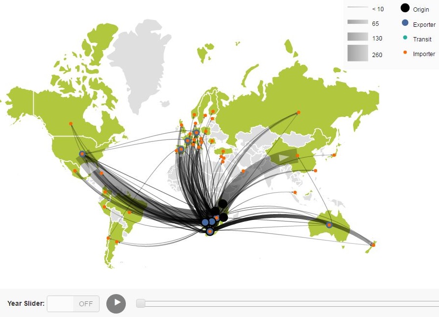
Xu, Z., Chau, S., Ruzzenenti, F., Connor, T., Li, Y., Tang, Y., Li, D., Gong, M., & Liu, J. "Evolution of multiple global virtual material flows". Science of The Total Environment, 658, 659-668. doi:10.1016/j.scitotenv.2018.12.169 [pdf]
2017
Meng, H.-W., Kath, S., Li, D., & Nguyen, Q. C. "National substance use patterns on Twitter". PLOS ONE, 12(11), e0187691. doi:10.1371/journal.pone.0187691 [pdf]
2017
Nguyen, Q., McCullough, M., Meng, H., Debjyoti, P., Li, D., et al. "Geotagged U.S. Tweets (2015-2016) as Predictors of County-Level Health Outcomes". American Journal of Public Health doi: 10.2105/AJPH.2017.303993 [pdf].
2017
Li, D., Cova, T.J., & Dennison, P.E. “Using reverse geocoding to identify prominent wildfire evacuation trigger points”. Applied Geography, 87, 14-27.doi: 10.1016/j.apgeog.2017.05.008 [pdf]
2017
Xu, Z., Tang, Y., Connor, T., Li, D., Li., Y., & Liu, J. "Climate variability and trends at a national scale". Scientific Reports. doi:10.1038/s41598-017-03297-5 [pdf]
2017
Nguyen, Q., Meng, H., Li, D.,Kath, S., et al. "Social media indicators of the food environment and state health outcomes". Public Health, 148, 120-128. doi:10.1016/j.puhe.2017.03.013 [pdf]
2017
Cova, T.J., Dennison, P.E., Li, D., Siebeneck, L.K., Drews, F.A., & Lindell, M.K. "Warning triggers in environmental hazards: who should be warned to do what and when?" Risk Analysis, 37(4), 601-611. doi:10.1111/risa.12651 [pdf]
2016
Nguyen, Q., Li, D., Meng, H., Kath, S., Nsoesie, E., Wen, M., & Li, F. "Building a national neighborhood dataset from geotagged Twitter data for indicators of happiness, diet, and physical activity". JMIR Public Health & Surveillance. doi:10.2196/publichealth.5869 [pdf]
2016
Nguyen, Q., Kath, S., Meng, H., Li, D., Smith, K., VanDerslice, J.A., Wen, M., & Li, F. "Leveraging geotagged Twitter data to examine neighborhood happiness, diet, and physical activity". Applied Geography, 73, 77-88. doi:10.1016/j.apgeog.2016.06.003 [pdf]
2015
Li, D., Cova, T.J., & Dennison, P.E. “A household-level approach to staging wildfire evacuation warnings using trigger modeling”. Computers, Environment, and Urban Systems, 54, 56–67. doi:10.1016/j.compenvurbsys.2015.05.008 [pdf]
2013
Guo, X., Cheng, C., Tan, Y., & Li, D. “Study on Unified Encoding Method for Topographic Map Based on Subdivision Framework”. Periodical of Ocean University of China, 44(3). (in Chinese)
2010
Geng, X., Cheng, C., Song, S., & Li, D. “Global Subdivision Systems Based on Map Kilo-Grids”. Geography and Geo-Information Science, 2(3). (in Chinese)
2018
Li, D. “Geocoding and reverse geocoding". In Cova, T.J. & Tsou, M. (Eds.), Comprehensive Geographic Information Systems. Vol. 1, Elsevier. doi: 10.1016/B978-0-12-409548-9.09593-2 [pdf]
2015
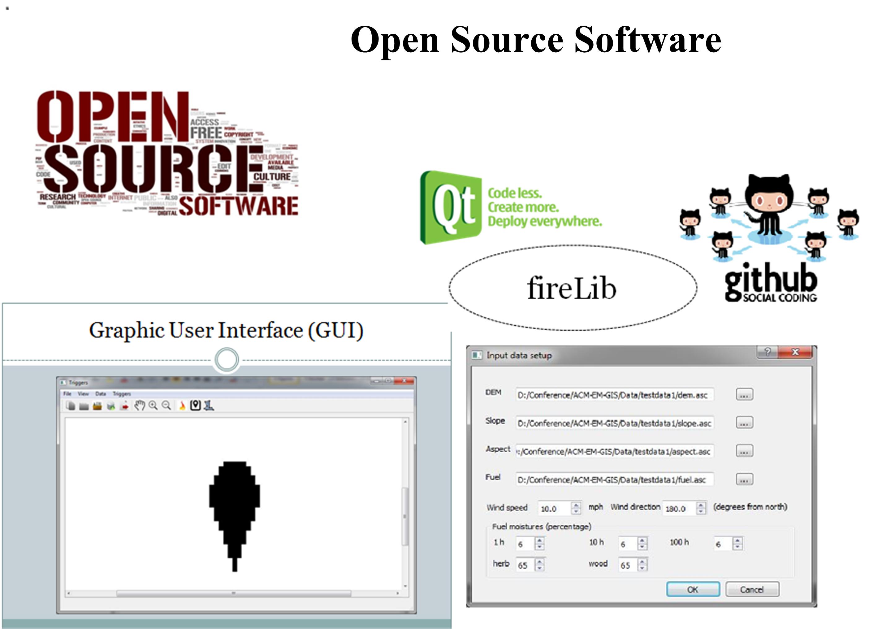
Li, D., Cova, T.J., & Dennison, P.E. “An open-source software system for setting wildfire evacuation triggers”. 1st ACM SIGSPATIAL International Workshop on the Use of GIS in Emergency Management. doi: 10.1145/2835596.2835600 [pdf]
2010
Li, D. & Cheng, C. "A proposed architecture for emergency response systems based on Digital Earth". Proc. SPIE 7840, the Sixth International Symposium on Digital Earth: Models, Algorithms, and Virtual Reality.
2015
Li, D., Cova, T.J., & Dennison, P.E. “Establishing wildfire evacuation zones—a coupled human-environmental system approach”. Proceedings of the 13th International Wildland Fire Safety Summit & 4th Human Dimensions of Wildland Fire Conference. (Extended abstract)
2019
Li, D. “Transportation infrastructure in disaster resilience assessment”. GIS Professional, 291, 12-14. [pdf]
2010
Qi, Y., Li, D., Fang, W., et al. “Using Build Forge to Install Tivoli Provisioning Manager”. IBM SSPD database, Document ID: TD105637.
2019
“ In the Age of Fast-Moving Fires, What's the Best Way to Get People Out?”. KQED Science (Living With Wildfire: California Reimagined Series), June 3. (Reporter: Jeremy Siegel).
2020-
Instructor
GEOG 790 Seminar: GIS Programming (Python Programming with ArcGIS) [Syllabus]
2019-
Instructor
GEOG 786: Geographic Information Systems [Web GIS] [Python programming]
2017-
Instructor
GEOG 372: Introduction to Geographic Information Systems [Syllabus]
2017-
Instructor
GEOG 474/574 GIS: Vector and Raster Modeling [Syllabus]
2014
Instructor
GEOG 5140: Methods in GIS (an advanced GIS course)
2013
Guest Lecturer (teaching practicum)
GEOG 5180/6180: GIS & Python (ArcPy section)
2020-
GEOG 471/571: Introduction to GIS Programming (Python Programming)
2019
GEOG 790 Seminar: GIS Programming (Python Programming)
2019
GEOG 473/573: GIS Data Creation & Integration
2019
GEOG 476/576: Web GIS
2018
GEOG 786: Geographic Information Systems (Advanced Web GIS)
2018
GEOG 477/577: Spatial Databases (PostgreSQL/PostGIS)
2017
GEOG 474/574: GIS: Vector & Raster Modeling
2017
GEOG 372: Introduction to Geographic Information Systems
2014
GEOG 1180: Introduction to Geo-Programming (Python programming)
2019
Instructor. Technical Training Session: Basics of Scripting with Python. The 2019 Black Hills Digital Mapping Agency Conference, Rapid City, South Dakota, U.S.A.
2019
Instructor. Technical Training Session: Using Python in Geocoding/Reverse Geocoding. The 2019 Black Hills Digital Mapping Agency Conference, Rapid City, South Dakota, U.S.A.
2018
Instructor. Technical Training Session: Introduction to Git. The 2018 Black Hills Digital Mapping Agency Conference, Rapid City, South Dakota, U.S.A.
2022
Li, D. “A data-driven approach to improving evacuation time estimates for resort communities during wildfires”. The 2022 Black Hills Digital Mapping Agency Conference, Rapid City, SD, U.S.A. (Virtual)
2022
Li, D. “Modeling Protective Action Triggers in Wildfire Evacuation: Challenges and Opportunities”. Great Plains Rocky Mountains Association of American Geographers Annual Meeting, Denver, CO, U.S.A.
2022
Khan, S.N., Li, D., & Maimaitijiang, M. “Geographically Weighted Machine Learning to Predict Corn Yield in the U.S. Corn Belt”. Great Plains Rocky Mountains Association of American Geographers Annual Meeting, Denver, CO, U.S.A.
2022
Li, D. “A data-driven approach to improving evacuation time estimates for resort communities during wildfires”. Association of American Geographers Annual Meeting, New York, NY, U.S.A. (Virtual)
2021
Li, D. “An Introduction to Geocoding and Reverse Geocoding”. South Dakota Statewide Geospatial Conference, U.S.A. (Virtual)
2021
Li, D. “Why do We Need a National Address Point Database to Improve Wildfire Public Safety in the U.S.?”. South Dakota Statewide Geospatial Conference, U.S.A. (Virtual)
2021
Li, D. “A data-driven approach to improving wildfire evacuation time estimates in resort areas”. The 16th International Wildland Fire Safety Summit and 6th Human Dimensions conference, U.S.A. (Virtual)
2021
Li, Y., Wang, S., Cao, G., Li, D., & Ng, B.P. “Disentangling Racial/Ethnic and Income Disparities of Food Retail Environments and Obesity Prevalence”. Association of American Geographers (AAG) Annual Meeting, Seattle, Washington, U.S.A. (Virtual)
2021
Dwomoh, K. & Li, D. “Using GIS and Big Data to Map Wildland-Urban Interface in California, USA”. Association of American Geographers (AAG) Annual Meeting, Seattle, Washington, U.S.A. (Virtual)
2021
Li, D. “Wildfire evacuation modeling in the big data era: Opportunities and challenges”. Association of American Geographers (AAG) Annual Meeting, Seattle, Washington, U.S.A. (Virtual)
2020
Li, D. “Using Computer Models, Big Data, and GIS to Improve Community Wildfire Evacuation Planning”. AutoCarto 2020, U.S.A. (Virtual)
2020
Li, D., Li, Y., Nguyen, Q.C., & Siebeneck, L.K. “Mapping the Certified GIS Professionals in the U.S.”. Applied Geography Conference, U.S.A. (Virtual)
2020
Li, D. “Mapping the Certified GIS Professionals (GISPs) in the U.S.”. GIS in the Rockies, Denver, Colorado, U.S.A. (Virtual)
2019
Li, D. “An introduction to the GIS Professional (GISP) certification program”. The 2019 Black Hills Digital Mapping Agency Conference, Rapid City, South Dakota, U.S.A.
2019
Li, D. “A study on the GISP Certification program in the U.S.”. The Annual Meeting of the Great Plains-Rocky Mountain Division of the Association of American Geographers, Lawrence, Kansas, U.S.A.
2019
Li, D. “An introduction to ArcGIS Collector”. South Dakota Statewide Geospatial Conference, Mitchell, South Dakota, U.S.A.
2019
Li, D. “An introduction to online geocoding and reverse geocoding services”. South Dakota Statewide Geospatial Conference, Mitchell, South Dakota, U.S.A.
2019
Li, D. “A preliminary study on the GISP program in the U.S.”. South Dakota Statewide Geospatial Conference, Mitchell, South Dakota, U.S.A.
2019
Li, D., Cova, T.J., & Dennison, P.E. “Coupling fire and traffic simulation models to set wildfire evacuation triggers”. Association of American Geographers (AAG) Annual Meeting, Washington DC, U.S.A.
2019
Wan, N., Li, D., Cho, L., & Wetter, D. “Applying mobile technologies in public health research: challenges and opportunities for geographers”. Association of American Geographers (AAG) Annual Meeting, Washington DC, U.S.A.
2018
Li, D. “Using online reverse geocoding services to set wildfire evacuation triggers”. The 2018 Black Hills Digital Mapping Agency Conference, Rapid City, South Dakota, U.S.A
2018
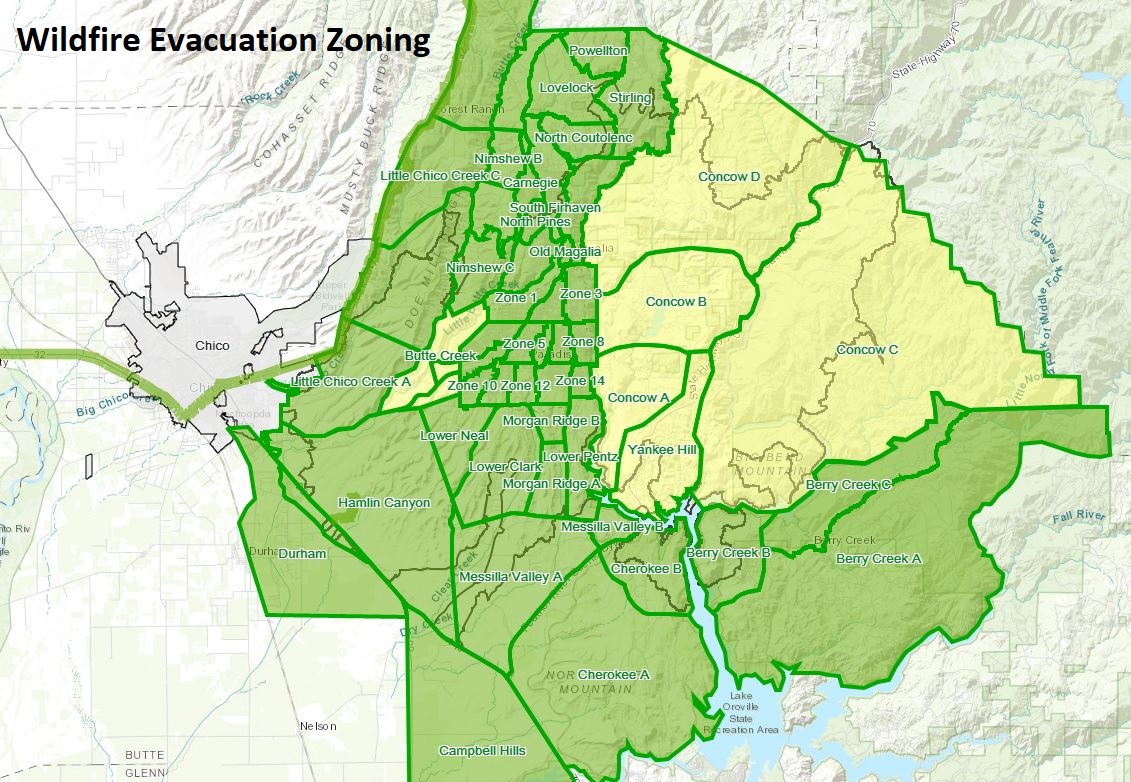
Li, D. “A preliminary examination of wildfire evacuation zoning: Evidence from the Vineyard Fire and the Carr Fire”. The 2018 Annual Meeting of the Great Plains-Rocky Mountain Division of the Association of American Geographers, Manhattan, Kansas, U.S.A.
2018
Li, D., Cova, T.J., & Dennison, P.E. “Coupling fire and traffic simulation models to set wildfire evacuation triggers”. The 4th Fire and Evacuation Modeling Technical Conference, Gaithersburg, Maryland, U.S.A. [Video]
2018
Li, D. “Modeling wildfire evacuation triggers using open GIS”. Association of American Geographers (AAG) Annual Meeting, New Orleans, Louisiana, U.S.A.
2017
Li, D., Cova, T.J., & Dennison, P.E. “Identifying prominent wildfire evacuation trigger points with reverse geocoding”. Great Plains/Rocky Mountains Division of the American Association of Geographers Annual Meeting, Grand Forks, North Dakota, U.S.A.
2017
Li, D. “An open source tool for tracing international food trade flows under the telecoupling framework”. Association of American Geographers (AAG) Annual Meeting, Boston, Massachusetts, U.S.A.
2016
Li, D., Cova, T.J., & Dennison, P.E. “Setting wildfire evacuation triggers by coupling fire and traffic simulation models”. The 5th International Fire Behavior and Fuels Conference, Portland, Oregon, U.S.A
2016
Li, D., Cova, T.J., & Dennison, P.E. “Setting wildfire evacuation triggers by coupling fire and traffic simulation models: a spatiotemporal GIS approach". Association of American Geographers (AAG) Annual Meeting, San Francisco, California, U.S.A.
2016
Cova, T.J., Li, D., & Dennison, P.E. “Spatio-temporal representation issues in modeling evacuation warning triggers”. Association of American Geographers (AAG) Annual Meeting, San Francisco, California, U.S.A.
2015
Li, D., Cova, T.J., & Dennison, P.E. “Promote Open Science in Wildfire Evacuation Modeling: An Open-Source Software System for Setting Wildfire Evacuation Triggers”. The 26th Quarterly Salt Lake GIS Users Group (SLUG) Meeting, Salt Lake City, Utah, U.S.A.
2015
Li, D., Cova, T.J., & Dennison, P.E. “An open-source software system for setting wildfire evacuation triggers”. The 1st ACM SIGSPATIAL International Workshop on the Use of GIS in Emergency Management (EM-GIS), Seattle, Washington, U.S.A.
2015
Li, D., Cova, T.J., & Dennison, P.E. “Integrating fire-spread and household-level trigger modeling to stage wildfire evacuation warnings”. Geocomputation 2015, Dallas, Texas, U.S.A.
2015
Li, D., Cova, T.J., & Dennison, P.E. “Setting wildfire evacuation triggers by coupling traffic simulation, trigger modeling, and reverse geocoding”. Association of American Geographers (AAG) annual meeting, Chicago, Illinois, U.S.A.
2015
Li, D., Cova, T.J., & Dennison, P.E. “Establishing wildfire evacuation zones—a coupled human-environment system approach”. Managing Fire, Understanding Ourselves: Human Dimensions in Safety and Wildland Fire, Boise, Idaho, U.S.A.
2014
Li, D., Cova, T.J., & Dennison, P.E. “Household-level wildfire evacuation trigger modeling”. AutoCarto 2014, Pittsburgh, Pennsylvania, U.S.A.
2014
Li, D., Cova, T.J., & Dennison, P.E. “A framework for improving the use of online reverse geocoding services”. Association of American Geographers (AAG) annual meeting, Tampa, Florida, U.S.A.
2013
Li, D. & Cova, T.J. “Using geotagged tweets to explore geographic disparities of Twitter users: a case study of New Jersey state, U.S.”. CaGIS/ASPRS 2013 Specialty Conference—Imaging and Mapping for Disaster Management: From the Individual to the Global Community, San Antonio, Texas, U.S.A.
2014
Li, D., Cova, T.J., & Dennison, P.E. “Household-level wildfire evacuation trigger modeling”. Maps on the Hill, Salt Lake City, Utah, U.S.A.
2013
Li, D. “Social media in natural disasters: mapping tweet density in Hurricane Sandy”. Maps on the Hill, Salt Lake City, Utah, U.S.A.
2009
Li, D. & Cheng, C. "A proposed architecture for emergency response systems based on Digital Earth". The Sixth International Symposium on Digital Earth, Beijing, China.
2016
Finalist for the Student Honors Paper Competition, Geographic Information Science and Systems Specialty Group, Association of American Geographers
2015
Jeanne X. Kasperson Student Paper Award, Hazards, Risks, and Disasters Specialty Group, Association of American Geographers
2016
Student Travel Award, the Associated Student of University of Utah (ASUU)
2015
Travel Award for Transportation and Communities Summit 2015, Point B: University of Utah Transportation Student Group
2015
NSF Travel Award for San Diego Supercomputer Center (SDSC)'s Summer Institute 2015
2015
NSF Travel Award for the 13th International Conference of GeoComputation
2015
Student Travel Award, the Associated Student of University of Utah (ASUU)
2014
Graduate Student Travel Award, the Graduate School of University of Utah
2013
Graduate Student Travel Award, the Graduate School of University of Utah
2010
Second-class Scholarship for Graduate Student, Peking University
2009
Second-class Scholarship for Graduate Student, Peking University
2008
First-class Scholarship for Graduate Student, Peking University
2007
Sino Petroleum & Chemical Scholarship, China University of Geosciences (Beijing)
2006
First-class Professional Scholarship, China University of Geosciences (Beijing)
2005
First-class Professional Scholarship, China University of Geosciences (Beijing)
2005
Second-class National Scholarship, China University of Geosciences (Beijing)
2006
Study Model of China University of Geosciences (Beijing)
2005
Third Prize in Mathematics Competition, China University of Geosciences (Beijing)
2005
Second Prize in the 2005 National English Contest for College Students
Programming Languages
Python, C/C++, Java, R, Perl, Matlab, IDL
Web Development
HTML, CSS, JavaScript, Apache HTTP/Tomcat Server
Mobile Development
Android, iOS, eMbedded Visual C++
WebGIS Development
OpenLayers, Leaflet, GeoServer, PostGIS, ArcGIS Server/ArcSDE
High Performance Computing
OpenMP, MPI, GPU, SLURM Scheduler, Kepler, gprof, IPython
Linux/Unix Skills
RedHat/Ubuntu Linux, Bash, Vim, Linux/Unix system programming
IDEs
Visual Studio, Eclipse, PyCharm, Android Studio, Xcode, WebStorm
Database Skills
PostgreSQL/PostGIS, SQL Server, DB2, MySQL, MongoDB
Software Development Tools
Git, SVN, Microsoft Visio, Rational Rose, Build Forge
Software Development Kits
ArcObjects/ArcEngine, OpenGL, Qt, VTK, ILOG CPLEX, Gurobi
GIS/Remote Sensing Tools
ArcGIS/ArcPy, ENVI, ERDAS IMAGINE, QGIS, Google Earth Engine
Agent-Based Modeling Tools
NetLogo, Repast, MATSim (traffic simulation)
Open Source Geospatial Tools
GDAL/OGR, OpenTools, PROJ.4, JTS, JOSM
Fire Spread Modeling Tools
FlamMap, FarSite, FireFamilyPlus, BehavePlus, fireLib
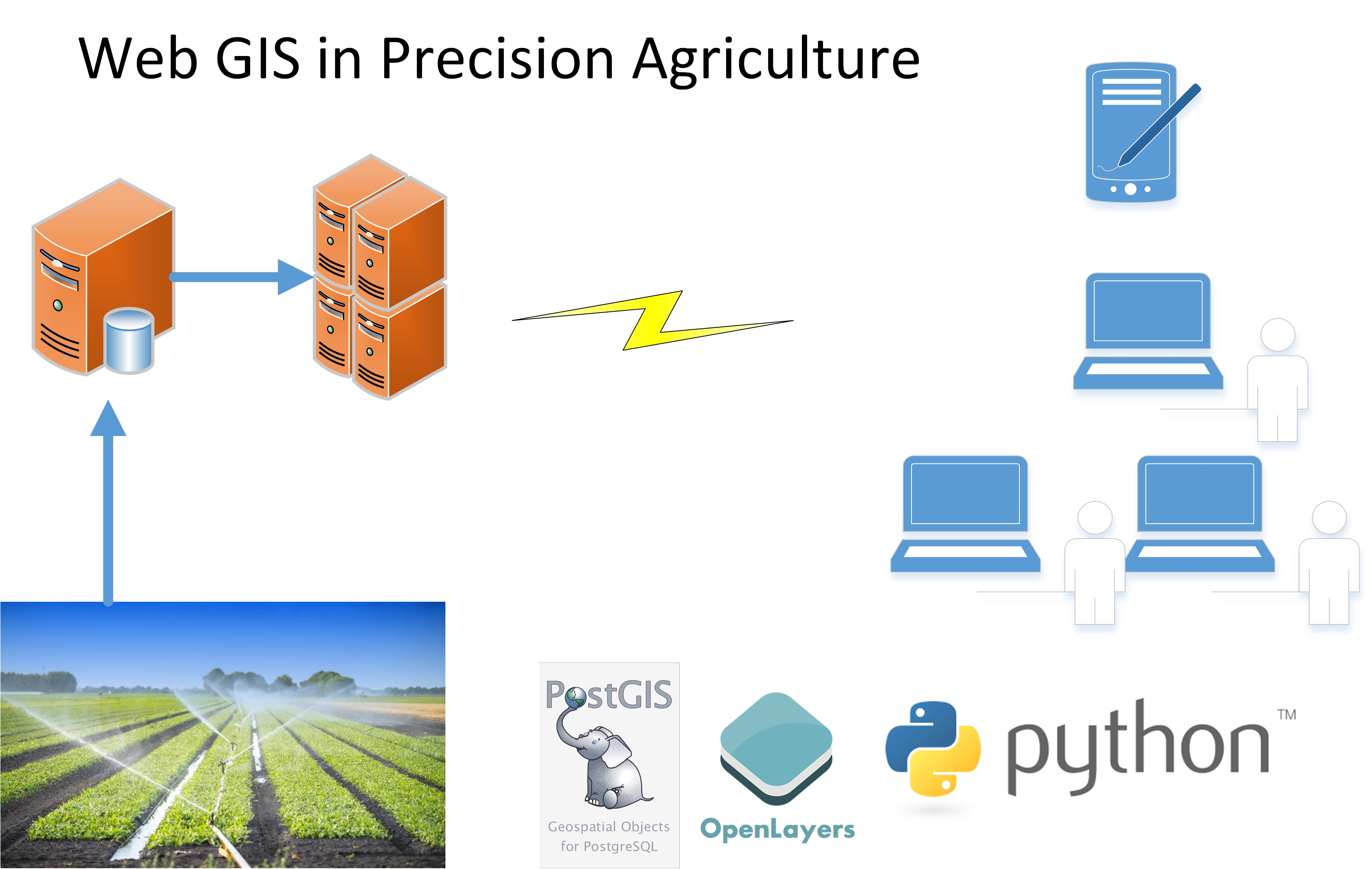
My recent research projects focus on: 1) Using big data to improve wildfire evacuation modeling and planning; 2) The development and use of open source Web GIS in wildfire evacuation, public health, and precision agriculture applications. My detailed research interests are as follows:
GIS:
Geoinformatics, Systems Modeling, Web GIS, Mobile Computing, Open Source GIS
Hazards:
Evacuation analysis/modeling/planning, disaster informatics
Public Health:
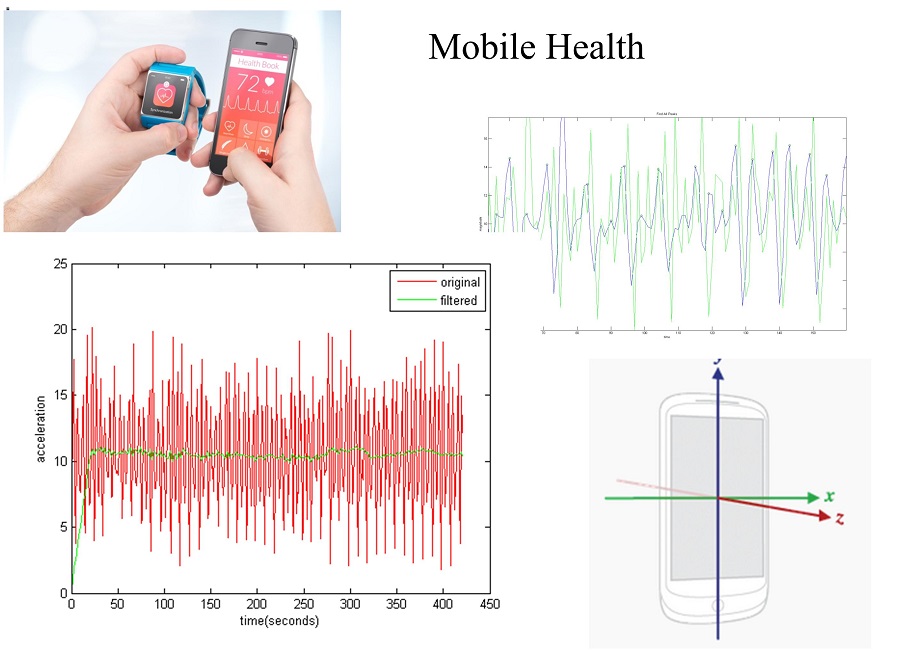
Big Data, Health Informatics, Mobile Health
Transportation:
Traffic Simulation, Transportation Planning, Public Transit
Sustainability:
Global Sustainability, Telecoupling, Food Security, Land Use Change
Agriculture:
Precision Agriculture, Agro-Informatics
I have been doing research and development in GIS and its applications for over ten years. I enjoy working with scholars, stakeholders, and businesses and using my expertise to help them succeed. Please feel free to contact me if you need technical support in your research or project.
I am interested in working with motivated students to study GIS and its applications in hazards, public health, transportation, sustainability, and agriculture. As funded Research Assistant positions become available, I will post the information here and on other job boards (e.g., AAG website). The Department of Geography and Geospatial Sciences will have 4~6 Teaching Assistant positions available every year. The Master's and Ph.D. programs are both STEM programs (more information). In addition, we have advanced computing resources in the department (more information). I strongly encourage those who want to pursue a career in GIS to reach out to me and send me a copy of your CV and a summary of your expertise and research interests.
I enjoy involving motivated undergraduate students in my research. I encourage those who want to develop strong GIS skills (especially those who want to be GIS developers) to contact me. I will figure out how to fit you into my research projects and help you develop a career plan.
Name:
Dapeng Li
Email:
dapeng.li[at]ua[dot]edu
Telephone:
TBD
Mailing Address:
Department of Geography, The University of Alabama
204 Farrah Hall, 513 University Boulevard, Tuscaloosa, Alabama 35487-0322, USA
Website:
Webpages